The Esplanade and Mill Street Connection project aims to make travel on the street safer and more inviting for people walking, cycling and taking transit, while maintaining access to local and citywide destinations. A final recommendation for the project was approved at Infrastructure and Environment Committee and City Council (IE22.11) in spring of 2021. The project is being implemented in phases, beginning in fall 2021, with Phase 3 to begin later in 2025.

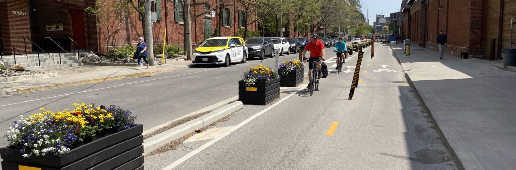
Phase 1, which included the installation of a bikeway on The Esplanade and Mill Street from Bayview Avenue to Lower Sherbourne Street, was installed in fall 2021. The improvements added safety upgrades such as reduced speed limits, improved intersection design, protected bike lanes and directional changes to Mill Street, Bayview Avenue and The Esplanade.
Phase 1 Information Booklet (December 2021)
Phase 2a, which included the installation of a bikeway on The Esplanade from Lower Sherbourne Street to Lower Jarvis Street, was installed in the spring 2022. The improvements added safety upgrades such as reduced speed limits, improved intersection design, protected bike lanes and directional changes to The Esplanade.
Phase 2a Information Booklet (May 2022)
Phase 2b involves the installation of a two-way cycle track on the south side of The Esplanade, from east of Yonge Street to Market Street. This work is being constructed as part of the City’s watermain and sewer replacement project, which began in 2024 and is expected to be completed by June 30, 2025.
For full details see the Phase 2b design details accordion.
Construction Notice – March 2024
Construction Update Notice – December 2024
Construction Update Notice 2 – March 2025
The installation of Phases 1, 2a, and 2b primarily use quick-build materials. This allows the City to collect data and understand how these changes affect traffic patterns, implement changes in phases, and make minor adjustments before permanent construction. In Phase 3, which is planned to begin in fall 2025, the City will be upgrading the existing bikeways to more seamlessly integrate with the streetscape, as well as connect the bikeway between Market Street and George Street South and create a continuous east-west cycling connection from Yonge Street to Bayview Avenue. This work will be done in conjunction with the . This work will include:
Community feedback continues to shape the refinement of the installation as opportunities arise.
Future phases will be identified for opportunities to upgrade The Esplanade between Market Street and Yonge Street, such as through future road works. Transportation Services is also working with various City agencies, including the St. Lawrence Centre for the Arts Redevelopment Project and the Old Town Toronto Business Improvement Area, as well as with other area private development applications, on their designs for the area and to incorporate opportunities to upgrade the bikeway or install other safety and accessibility improvements. This collaboration is to ensure the transportation network meets the needs of current and future residents, businesses, and organizations.
A block-by-block approach was taken to balance the needs of all travel modes: walking and rolling, cycling, transit, and driving. Curbside uses such as parking, commercial loading, motorcoach stops, and accessible loading were thoroughly reviewed. Careful attention has been paid to maintaining access to all parking garages and loading docks on The Esplanade, Scott Street, Church Street and Market Street, as well as property access for emergency services vehicles.

Between Yonge Street and Scott Street, The Esplanade will remain two-way for drivers, alongside the two-way cycle track on the south side. Access for driving on this block is important for westbound TTC buses, as well as larger vehicles servicing businesses and event spaces in the area.
The Esplanade is currently designated as “No Parking” between Scott Street and Yonge Street. This will become “No Standing” on the north side, which allows for on-demand passenger loading such as pick-off/drop-off and ride hailing but does not allow for commercial loading or other uses where people leave their vehicle unattended such as food deliveries. The south side will generally become “No Stopping” to maintain sight lines at driveways and intersections and to ensure the roadway is available to move vehicles such as TTC buses.
Based on feedback received during the consultation process, an accessible loading zone for people with disabilities will be added on the south side in front of 25 The Esplanade. A raised platform will be provided to facilitate access across the cycle track by persons with a disability, where cyclists are required to yield to passengers loading across the cycle track. The City will monitor this location following installation to determine if further changes are necessary.
Deliveries to businesses and residents between Yonge Street and Scott Street can be made from either the parking garages or from Scott Street, where on-street parking and loading will remain unchanged from today, including the 20-minute loading zone for deliveries just north of The Esplanade. Access to the Green P parking garage will be maintained on the south side between Scott Street and Yonge Street; access to the garage from Church Street and Market Street south of The Esplanade will remain unchanged.
Between Scott Street and Church Street, The Esplanade will become one-way westbound for motor vehicles. Access will be maintained for westbound TTC buses, as well as to the Novotel and the Green P parking garage. Making this block one way for drivers serves three main purposes:
The Novotel and parking laneway east of Scott Street will be accessible from The Esplanade for westbound drivers. Allowing eastbound access on The Esplanade from Scott Street to the parking access at the Novotel laneway is not possible due to lack of roadway space.
Between Scott Street and Church Street, The Esplanade is currently signed as “No Standing” on the south side. This will be changed to “No Stopping” to maintain westbound motor vehicle and bus travel; a new bike share station will also be added in front of the Novotel on the south side of the roadway.
On the north side, on-street parking is currently provided, as well as a commercial loading zone and TTC bus stop. As part of Phase 2b installation, the west half of the block will be signed as “No Stopping”; the east half of the block will include a new passenger loading zone for passenger pick-up/drop-off such as ride hailing and motor coach loading for the Novotel. As the block will be one-way westbound, hotel patrons accessing the Novotel can be dropped off on the north side of the roadway and cross to the south side, utilize the hotel’s semi-circular covered entrance on the south side of the roadway, or park in and enter via the hotel’s underground parking garage.
The existing commercial loading zone on the north side will be maintained for deliveries, as will approximately four on-street parking spaces. Loading is also permitted in the “No Parking” zone on Church Street north and south of The Esplanade within 30m of the intersection. The City will monitor this block following installation to determine if additional changes are required to manage curbside needs such as passenger pick-up/drop-off, motorcoach loading, and commercial and accessible loading.
Between Church Street and Market Street, The Esplanade will remain two-ways for motor vehicles to maintain access to Market Street south of The Esplanade. This will maintain service for eastbound and westbound TTC buses, as well as general purpose traffic.
The Esplanade currently has on-street parking on the north and south sides of the roadway between Church Street and Market Street. To accommodate the two-way cycle track on the south side and maintain two-way vehicle traffic, parking will be prohibited on both sides of the roadway. More than 2,000 parking spaces are available in the Green P lot to the south and on other nearby roadways.
The majority of the south side will become “No Stopping” to ensure the roadway is available to move vehicles such as TTC buses. However, the existing accessible loading zone adjacent to 115 The Esplanade will be maintained, and a raised platform will be provided to facilitate access across the cycle track by persons with a disability, where people cycling are required to yield to passengers loading across the cycle track.
The north side will become “No Stopping” between Market Street and a point approximately 60 metres west to ensure the two-way traffic is not blocked by passenger loading in the accessible zone on the south side of the roadway. The remaining length of the north side will become “No Standing” to allow for on-demand passenger loading such as pick-off/drop-off and ride hailing. Commercial loading and other uses where people leave their vehicle unattended such as food deliveries. Commercial loading is still possible on Church Street, as noted previously.
The City will monitor this block following installation to determine if additional changes are necessary, such as signage, pavement markings or additional loading zones.
Maintaining access to entrances, exits, loading areas and garages is critical to all street design projects. Through consultation, observation and truck turning design tools, the project team identified these areas and have maintained access across the corridor, including with the new southside bikeway and street direction changes.
Accessibility is also a priority. Based on feedback from Wheel Trans and building managers, the design maintains access to buildings with a high population of seniors and people with mobility needs. The design will be maintaining the accessible access to 115 The Esplanade and adding a new accessible loading zone in front of 25 The Esplanade. This design will include a raised platform across the bikeway to maintain Wheel Trans service and other passenger loading activities at sidewalk level.
The City will continue to monitor the project area following installation to determine if additional changes are required to manage curbside needs such as passenger pick-up/drop-off, motorcoach loading, and commercial and accessible loading.
After installation, the project is not yet complete. The City is committed to monitoring projects after installation to better understand how usage patterns and how they can be further tailored to suit the community. There is usually an adjustment period when changes are made to a street while people update their travel patterns, but the City does not expect there to be significant impacts due to the safety improvement project.
Preliminary data shows that daily bicycle volumes have approximately doubled on The Esplanade since installation of the two-way bikeway on the south side of the corridor.
Traffic volumes on The Esplanade and Mill Street were reduced by approximately 75% and 58%, respectively. Several segments are below the maximum vehicle volume threshold for Neighbourhood Greenway projects, while some segments are slightly above. As the remaining phases are implemented, staff will monitor motor vehicle volumes to ensure they remain at or below Neighbourhood Greenway threshold levels.
Download Phase 1 and 2A Data Analysis and Project Update
Following completion of Phases 2b and 3, potential impacts will be studied through post-implementation traffic counts – the City will consider both the data collected approximately six to 12 months following completion of the project alongside public feedback. Based on this review, City Staff may recommend to City Council adjustments to address operational and safety concerns.
Public Consultation took place from October 2019 to March 2021 to introduce the project to the community and identify overall needs and priorities. The consultation reports linked below provide a detailed summary of all activities that took place and feedback received.